Google Maps partners with The Catlin Seaview Survey for underwater images
Google Maps has partnered with a specialist marine organisation to expand its imaging to selected underwater environments. The Catlin Seaview Survey has been documenting the health of Australia’s Great Barrier Reef using a specially-designed underwater camera.
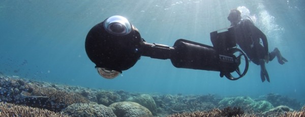
Underwater Earth runs The Catlin Seaview Survey and had the SVII camera specially developed for the task. The camera is ‘driven’ through coral reefs on a specialised scooter and a trio of extreme-wide-angle cameras mounted in its head take photos every three seconds. This is the raw data that’s then re-formatted on a computer.

Richard Vevers is Project Director at Underwater Earth: “These [images] are then stitched together to give a full 360-degree panorama which can be linked to form a virtual dive experience. On average the camera takes about a thousand high-resolution panorama images on a single survey dive.”
The environment itself is the biggest challenge to overcome because the cameras have to be put in the right place in the waterproof housing and matched with the correct lens, which isn’t all that easy to get right when filming underwater. Then there’s the problem of visibility on murky days.
On average the camera takes about a thousand high-resolution panorama images on a single survey dive.
Richard Vevers, Underwater Earth
Surveying the Barrier Reef is scheduled to last three months and probes depths of 100 metres, before the organisation moves on to the Philippines, Bermuda and Hawaii in 2013. Catlin’s SVII is a privately-owned piece of equipment.
Google is already renowned for its Street Map function and now users can dive into the ocean in selected locations to see what’s going on below the waves.
(Stills images: Catlin Seaview Survey)
Related Posts
- David Attenborough to film new BBC documentary on Great Barrier Reef
- Partizan travels from Mexico to Alaska for Honda and films with a 360-degree camera
- Underwater filming equipment explored
- Archer’s Mark films underwater Mexican cave for Ballantine’s Scotch whisky
- Will Smith films sci-fi epic After Earth on location in US and Central America
- Modern Family TV comedy to film holiday show in Queensland and Sydney
- Blue Note Productions develops 3D underwater camera for Mexican caves
- Google Expeditions shoots VR film in Siberia
Related posts:
Global Filming Incentive - Australia (see more…)
Comments
Not Logged in
You must be logged in to post a comment
There are no comments